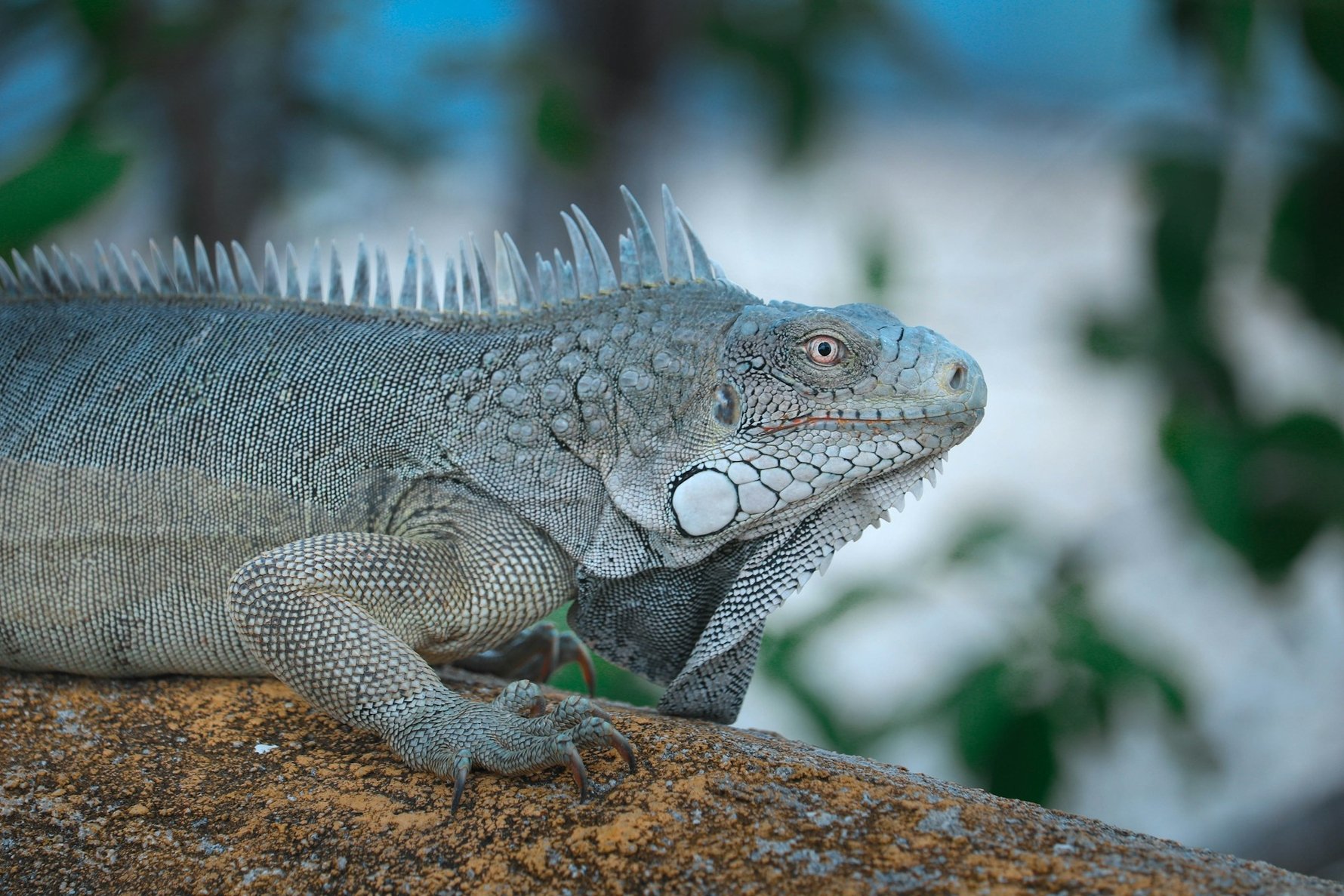
Bonaire is the quietest of the ABC islands and, depending on your priorities, either the most rewarding or the least eventful. There are no casinos, no resort strip, no nightclub district to speak of, and the capital has a population of around 15,000 people whose main relationship with the sea is not tourism but conservation. What the island does have is one of the healthiest and most accessible coral reef systems in the Caribbean, an unusual landscape of pink salt pans and towering cacti, two national parks covering more than a third of the island’s total area, and a flamingo population large enough to be genuinely startling the first time you round a bend and find several hundred of them standing in a pink lagoon.
The island sits 80 kilometres north of Venezuela, outside the hurricane belt, and is a special municipality of the Netherlands – not a country in its own right, as Aruba and Curaçao are, but a Caribbean version of a Dutch province. It is small, flat in the south and hilly in the north, covered in cacti and thorny scrub, and almost completely devoid of the usual Caribbean resort infrastructure. People come here to be in the water or to look at what lives in it. A nature fee of US$40 per person, purchased through STINAPA (the foundation that manages both national parks), is mandatory for anyone entering the water or visiting Washington Slagbaai National Park, and is valid for the calendar year. It is not optional, and rangers check.
The Bonaire National Marine Park was established in 1979 and was, at the time, the first underwater national park in the world. It encompasses all the waters surrounding Bonaire and the uninhabited islet of Klein Bonaire, from the high-tide line to a depth of 60 metres, covering roughly 2,700 hectares of coral reef, seagrass beds and mangrove forest. The reef is a narrow fringing reef that begins almost at the shoreline, which is what makes Bonaire unusual: 54 of the park’s 86 designated dive sites are accessible directly from shore without a boat. You drive to a yellow-painted rock marking the entry point, kit up, walk in, and the reef is immediately below you. The park contains 57 species of soft and stony coral and more than 350 recorded fish species, and visibility commonly exceeds 30 metres.
The park’s condition is largely a product of its rules, which are strict and consistently enforced. Anchoring within the park boundaries is prohibited – all boats use mooring buoys. Gloves are banned for divers. Spearfishing is banned. Touching coral is banned. Every certified diver who has not dived Bonaire in the current calendar year must complete a brief orientation dive with a local operator before diving independently. The park runs entirely on income from the nature fee, without government subsidies – a model that has been studied and replicated elsewhere in the Caribbean with mixed results. The reef has its problems: stony coral tissue loss disease has required temporary closures of some sites, including those in Washington Slagbaai National Park, and increased visitor numbers are putting pressure on the shallower sections. But by the standards of the wider Caribbean, where an estimated 50% of coral cover has been lost since the 1970s, Bonaire’s reef is exceptional.
Location: The entire coastline of Bonaire and Klein Bonaire. Shore dive sites are marked with yellow painted rocks along the western coastal road. Dive operators in Kralendijk offer equipment rental, guided dives and boat excursions.
Best time to visit: Year-round. Visibility and conditions are consistently good on the western (leeward) side. The windward east coast is rougher and largely inaccessible to divers.
What to budget: The STINAPA Nature Fee is US$40 per person, valid for the calendar year and covering both the marine park and Washington Slagbaai National Park. Snorkel gear rental costs around US$10–15 per day from dive shops. Guided boat dives typically cost US$50–80 per person including equipment.
Good to know: Check current site closures with STINAPA or your dive operator before heading out – disease-related closures can be implemented with little notice. Gear decontamination (soaking in a dilute bleach or Lysol solution) is required before your first dive on the island and after your last, to limit the spread of stony coral tissue loss disease.
The Salt Flats and Slave Huts
The southern third of Bonaire is occupied by a vast industrial salt operation that has been running, in one form or another, since the Dutch West India Company began exploiting the island’s natural salt pans in the 17th century. Today the facility is operated by Cargill, covers roughly 13% of the entire island, and produces between 300,000 and 500,000 metric tonnes of salt per year. The process is solar and gravitational: seawater drawn from the Caribbean moves through a succession of condenser ponds as the sun and trade winds evaporate it, the salinity increasing at each stage until, in the crystalliser ponds, the salt precipitates out of solution and forms a layer on the pond floor. The microorganisms that thrive in the hyper-saline water – halobacteria and algae containing carotenoid pigments – give the ponds their extraordinary colour range, from pale pink to deep magenta. At the end of the process the salt is stacked into the white pyramids, each roughly 15 metres high and containing around 10,000 metric tonnes of 99.6% pure salt, that greet visitors arriving by air.
Four coloured obelisks – red, white, blue and orange, matching the Dutch flag and the House of Orange – stand near the pans to guide ships to the correct loading point; they replaced the earlier method of lighting smoky fires on coral mounds. Alongside the white and orange pans, facing the sea, stand 30 small coral-stone huts built in 1850. Each measures approximately two metres by 1.5 metres, with a ceiling too low for a standing adult. In each hut slept between two and six enslaved people who worked the salt pans during the week. On Friday afternoons they were permitted to leave; their families lived in Rincón, the oldest settlement on the island, a seven-hour walk away. They returned on Sundays. The Dutch abolished slavery in the Antilles in 1863, thirteen years after these huts were built. The huts are preserved as they were found, with informational signs providing historical context. Flamingos wade in the saline lagoons immediately adjacent, apparently indifferent to the history of the place.
Location: Southern Bonaire along the EEG Boulevard coastal road, around 10–15 minutes by car south of Kralendijk. The slave huts are at two locations near White Pan and Orange Pan.
Best time to visit: Morning or late afternoon for the best light on the pink pans and the salt pyramids. Flamingos are present year-round in the lagoons; binoculars are useful for a closer look without disturbing them.
What to budget: Free. The coastal road is public and the sites are open at all hours.
Good to know: The Pekelmeer Flamingo Sanctuary at the southern tip of the island, adjacent to the salt works, is a protected nesting area for Caribbean flamingos and is closed to visitors to prevent disturbance during breeding season. The flamingos visible from the road are a different population feeding in the open pans.
Klein Bonaire
Klein Bonaire – Little Bonaire – is an uninhabited coral islet sitting 800 metres off the coast of Kralendijk, roughly four square kilometres in area, flat, covered in dry scrub and cactus, and surrounded by some of the healthiest reef in the entire marine park. The island was added to the Bonaire National Marine Park as a protected nature reserve in 2001 and has no permanent inhabitants, no facilities and no fresh water. Of the 132 sea turtle nests recorded on Bonaire in 2024, the majority were on Klein Bonaire’s beaches – hawksbill, green and leatherback turtles nest here between May and December, and the absence of human activity on the island is directly related to the health of those nesting populations.
The main reason to go is the reef. The waters around Klein Bonaire are calm, clear and consistently rated among the best snorkelling in the Dutch Caribbean, with coral gardens beginning at one metre of depth and green sea turtles grazing the seagrass beds in the shallows. No Name Beach on the northern side of the island is the one sandy beach, with no shade, no food, no facilities and water that is absurdly blue on a calm day. Water taxis depart from Karel’s Beach Bar on the Kralendijk waterfront and make the crossing in around ten minutes. The island closes to visitors in the afternoon during peak turtle nesting season to protect the nests; check current restrictions with STINAPA or your water taxi operator before going.
Location: 800 metres west of Kralendijk. Water taxis depart from Karel’s Beach Bar on the waterfront; the crossing takes around ten minutes.
Best time to visit: Morning, when the light is best and the reef is at its most vivid. The island can close to afternoon visitors during turtle nesting season.
What to budget: Water taxi return fare is around US$25 per person. Bring everything you need – food, water, snorkel gear, sunscreen – as there is nothing available on the island itself.
Good to know: The STINAPA Nature Fee covers snorkelling at Klein Bonaire. Rangers check at the landing points. No anchoring is permitted anywhere in the marine park; the water taxi operators use the designated mooring buoys.
Washington Slagbaai National Park
The northwestern third of Bonaire is occupied by the Washington Slagbaai National Park, 4,286 hectares of arid wilderness established in 1969 as the first nature sanctuary in the former Netherlands Antilles. The name reflects the park’s history: Washington was the northern plantation, whose workers collected their wages at a small office so important to them that they named it after the American capital; Slagbaai, meaning slaughter bay, was the southern one, named for the goats that were slaughtered there, salted and shipped to Curaçao. The two plantations were converted to a protected area in stages between 1968 and 1977. The remains of the plantation buildings are still visible within the park.
The park is driven by a one-way loop road – two routes, short and long, both unpaved and requiring a vehicle with reasonable ground clearance, though not necessarily a 4WD after the roads were graded in 2008. The landscape is rugged volcanic rock, towering cacti, dry riverbeds and coastal cliffs, with hypersaline lagoons (saliñas) where Caribbean flamingos feed year-round. The Goto Lake viewpoint, approached from the main road, offers one of the most arresting sights on the island: a body of water ringed by green hills with hundreds of flamingos visible from the shore, best at golden hour. The Brandaris hill at 241 metres is the highest point on Bonaire – the name is a corruption of the Dutch Brand, daar is (“there is fire”), recalling its earlier use as a signal point – and the hike to the summit takes around 45 minutes with panoramic views of the island, the sea and, on clear days, Curaçao. The yellow-shouldered Amazon parrot, endemic to Bonaire and listed as vulnerable, lives in the park; the ECHO conservation centre near the park entrance runs rehabilitation and breeding programmes for the species.
Location: Northwestern Bonaire; the park entrance is around 20 minutes by car north of Kralendijk. The park is open Tuesday to Sunday, 8am to 5pm; no entry after 2:30pm.
Best time to visit: Early morning for birdwatching and to avoid the midday heat on the hiking trails. The Goto Lake flamingo viewpoint is particularly good at sunrise and sunset.
What to budget: Covered by the STINAPA Nature Fee (US$40). No additional park entry fee. Bring substantial water – the park has no refreshment facilities and the trails are exposed.
Good to know: Diving is currently prohibited at the park’s coastal sites due to stony coral tissue loss disease. All other activities – hiking, birdwatching, swimming at the beaches, snorkelling at Playa Funchi – remain open. Check STINAPA for current status before visiting.
Lac Bay
On the sheltered eastern side of Bonaire, protected from the open Atlantic by a fringing coral reef, Lac Bay is a shallow turquoise lagoon that operates as several things simultaneously: a Ramsar-designated wetland of international importance, the largest mangrove forest in the Dutch Caribbean, a critical nursery for reef fish species, a feeding ground for sea turtles and flamingos, and one of the world’s most consistently rated windsurfing venues. The trade winds arrive at Lac Bay having crossed the open Caribbean with nothing to slow them down, and they do so at a reliable 15 to 25 knots for most of the year, over shallow, warm, protected water with no significant chop. The result is conditions that professional windsurfers travel specifically to train in – Lac Bay is a regular stop on the Professional Windsurf Association tour – and that beginners find unusually forgiving. Sorobon Beach at the lagoon’s western end has several windsurfing schools and rental operations. Kitesurfing is prohibited in the bay itself, to protect the ecosystem and the windsurfers, but is available at Atlantis Beach on the northern coast.
The ecological dimension of Lac Bay is equally significant. The mangrove forest fringing the lagoon functions as a nursery for more than 75% of the commercially important fish species in the wider Caribbean region. Kayaking into the mangroves with a certified guide is one of the quieter pleasures available on the island – the root systems are dense, the water is clear and shallow, and herons, ibises and occasionally flamingos are visible from the water. The seagrass beds in the centre of the lagoon are a regular feeding ground for hawksbill and green sea turtles. The pile of queen conch shells at Lac Cai on the lagoon’s northern edge – accumulated over generations of subsistence fishing, a practice now prohibited – is a small and quietly eloquent monument to how much things have changed.
Location: Southeastern Bonaire, around 15 minutes by car from Kralendijk. Follow the signs to Sorobon.
Best time to visit: For windsurfing, December to August for the strongest and most consistent winds. For birdwatching and kayaking, early morning when the wildlife is most active. The lagoon is pleasant at any time of year.
What to budget: Free to visit. Windsurfing rental and lessons from operators at Sorobon cost around US$50–80 per half day. Guided mangrove kayak tours run around US$30–50 per person.
Good to know: The STINAPA Nature Fee covers water activities in Lac Bay. Only certified guides may take visitors into the mangrove forest; independent kayaking into the mangroves is not permitted, to protect the ecosystem.
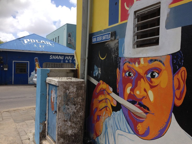
Kralendijk
Bonaire’s capital is a small, low-key waterfront town that functions with considerably less ceremony than Oranjestad on Aruba or Willemstad on Curaçao. The name – from the Dutch for coral dyke – reflects the practical relationship the settlement has always had with its coastline. The main street, Kaya Grandi, runs parallel to the sea and contains most of the island’s restaurants, dive shops and small hotels; the waterfront promenade behind it faces Klein Bonaire across a short stretch of open water. The painted buildings are bright but not aggressively so, the cruise ship terminal is on the northern edge of the centre, and on days when a ship is not in port the town reverts to a pace that most Caribbean capitals abandoned several decades ago. Fort Oranje, the small Dutch fortification at the southern end of the waterfront built in 1639, is the oldest building in Bonaire and still has its original cannons pointing out to sea, more for atmosphere than deterrence at this point.
The unusual closer in Kralendijk is the Cadushy Distillery, the only distillery in the Dutch Caribbean producing liqueur from the kadushi cactus – the tall columnar cactus (Cereus repandus) that dominates the island’s landscape and has been used medicinally and culinarily by the island’s population for generations. The distillery opened in 2013, uses only sustainably harvested kadushi, and produces a range of liqueurs that taste of the island in the way that mezcal tastes of Oaxaca: distinctively, without obvious precedent, and not immediately to everyone’s liking. The tasting room is in the centre of Kralendijk and the staff are reliably knowledgeable about both the product and the plant. It is the most Bonaire-specific thing you can drink.
Location: Kralendijk is on the western coast; the waterfront and Kaya Grandi are the centre of activity. The Cadushy Distillery is at Kaya Grandi 31.
Best time to visit: Early morning or early evening; midday in the sun is uncomfortable. On cruise ship days the town gets busier in the morning and quieter once the ship leaves in the afternoon.
What to budget: Walking the town costs nothing. Cadushy tastings are free or low-cost; bottles from around US$25.
Good to know: The giant flamingo sculpture on the Kralendijk waterfront, easily visible from the cruise terminal, is made from plastic waste collected from the ocean around Bonaire. It was created for the island’s annual Ocean Plastic Awareness campaign and is a more pointed piece of public art than it first appears.